
GeoPark in the City Park (Stadtpark)


View of the current GeoPark (left) and of the former City Park with the Secondary School behind to the right (picture above).
The Beautification Association of Münchberg petitioned the city magistrates in 1877 that across from the shooting range a plot of meadowland be made available for the development of a park. In the same year the area was planted with trees and paths were laid out. The area around the Shooting House along with the City Park was to form a continuous ensemble. Even at that time the Hofer Straße separated the two areas. For leisurely strolling it offered a peaceful environment, which invited one to pleasant morning walks. In 1893 and 1895 the park was extended to the newly built Park School. A year later came the annexation of the city water main network. In 1862 the so-called Court Square followed as a new expansion of the park.
 In 1904 an artificial fortress was laid out in the City Park as a new expansion of the park, which was called “Little Waldstein”, however it later fell victim to the extension of the hospital grounds. For this hill the dye factory Aktienfärberei placed a pavilion at the disposal, which would be placed on the East side of the park. A the time the City Park was favored as a meeting place, but students also played there during breaks. At that time the tall grown trees in between did not yet interfere with the view of the distance. In 1909 and 1911 the city park was once again enlarged and later on a children’s playground was built (photo below).
Changes followed in the next 50 years with the expansion of the hospital and in 1967 when the home for the aged was built.
The GeoPark was created in 2010 and informs visitors about the structure and the rock deposits of the geologically interesting “Münchberg Massif” and the surrounding mountain ranges based on numerous sample stones and panels.
Further information about the GeoPark in the Münchberg City Park can be found in a compilation of the City of Münchberg.

The Historic Münchberg Way begins in this spot and along the 44 stations we will take a trip through the last centuries of Münchberg’s past. Actually, the story of our area begins much earlier, therefore we will start here at the first HMW station with a look at the geological development of our region and begin our journey into the earth’s antiquity with a contribution from Prof. Dr. Ludwig Zöller and Prof. Dr. Dan Frost from the University of Bayreuth, which was acquired for our HMW project:
Fichtelgebirge, Frankenwald, Münchberg Massif – how it grew together, what belongs together today.
 This article gives a brief overview of the geological history of the area of Münchberg from the Paleozoic age to the present.
Paleozoic: The comprehensible history of the Münchberg district begins in the Paleozoic age (earth age 545 to 251 million years). The Fichtelgebirge, the Frankenwald and the Münchberg (gneiss) Massif are parts of the “Variscan Mountain Range” (named after the Germanic branch of the Variscans in the area of Hof, curia variscorum). The old mountain range, which is still visible in Europe, today is found between the Iberian Peninsula and Bohemia, especially in the secondary chain of mountains, which originally formed a large connected mountain range, which over long geologic erosion was leveled to large flat areas. In the course of the Alpidic mountain range formation the “Upper Cretaceous” period (beginning about 99 million years ago) the hulls of the Variscan Mountains were raised or lowered. From this originated the typical formation of our average mountain. Fichtelgebirge, Frankenwald and Münchberg Massif are raised hulls of the Variscan Mountains.
What appears to be a homogeneous mountain range today (for example Böhmerwald and Bayerischer Wald, Oberpfälzer Wald, Fichtelgebirge, Frankenwald, Münchberg Massif, Thüringer Wald), however, were originally formed together through the formation of the Variscan Mountains. This took place during the geological period of the Devons (beginning 410 million years ago) and reached its peak in our area in the Upper Carbon Epoch (330 to 296 million years ago). Previously km thick sediments were deposited in various ocean basins separated by small continents. (e.g. “Amorica”) and island arches. Through the movements of continental and oceanic plates the ocean floors were narrowed and oceanic plates pulled into the mantle (“subducted”) until the ocean floors were completely submerged and continental crusts in the suture zone came together. The movements of the original continent Godwana (original Africa) to the original continent Lurasia (original Europe) was decisive (graphic right). The Variscan Mountain Range was now grown together. In the process, the rocks were subject to great pressure and high temperatures in depths of up to several km, which led to severe deformations and recrystallizations (“metamorphic”). The structure of the Variscan Mountain Range in several zones testifies today to the collapse of parts originally removed and separated by ocean basins. One of these suture zones runs to the south of the Fichtelgebirge and separates the southern lying Moldanubian zone from the northern Saxothuringian zone. Toward the end of the mountain formation, rock melts also penetrated into the earth’s crust and solidified there in some depth (“Intrusion”). They form today, after the overlapping rocks have been eroded, the granite stones of the Fichtelgebirge.
Foreign matter “Münchberg Massif”: While the rocks of the Fichtelgebirge – with the exception of the intraditic rocks – and the Moldanubian zone have a moderate to high degree of metamorphose, they become increasingly weaker in southwestern Frankenwald from southwest to northeast. The exception here is the Münchberg Massif, which can be recognized by a much higher degree of metamorphosis as a kind of foreign body. The geologists already knew this at the beginning of the 20th century, but as they did not yet possess the theory of plate tectonics, they could not satisfactorily clarify the question of the origin and formation of the Massif. Today we assume that the Münchberg Massif as well as the further southeast yellow “Erbendorf-Vohenstrauß zone” (ZEV) represent remains of a far (up to 200km) shifted mountain mantle, whose present day main distribution area is in the “Tepla-Barrandium” in Bohemia. In the Münchberg Massif, these ceiling remains have been preserved in a dump location, since they are already eroded over the Fichtelgebirge. At the Weißenstein near Stammbach there are high metamorphic “eclogites” at the summit. They originated from former basalts of an ocean floor by sinking at a subduction zone at depths of 60 – 80 km. The pressure and temperature conditions of the eclogite formation can be recreated in high pressure laboratories such as the Bavarian Geoinstitute at the University of Bayreuth. Parts of these deeply buried rocks were forced up again by the later suture and pushed over other rocks as a blanket. Interestingly, today the eclogite of the Weißenstein – the only European eclogite north of the Alps – encases lower metamorphic rocks. In detail different phases of the long journey of the Weißenstein eclogite can be traced back to its present location, as illustrated in the following graphic: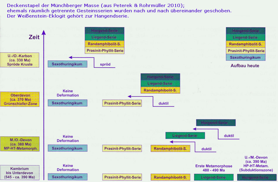
Mesozoic: In the Middle Ages (Mesozoic, 251 to 66 million years) northern Bavaria was partially the deposit area for terrestrial and marine sediments (partly in the northeast and east) but was also affected by uplift. Toward the end of the Paleozoic age there were tectonic processes on today’s northwest – southeast running “Franconian line”, which limits the Franconian Forest (Frankenwald) and the Fichtelgebirge on the south German stratigraphic stage with more than 1,000 m thick flat-bedded sedimentary rocks. At the beginning of the Mesozoic age, the Eastern Bavarian Basin as part of the Bohemian Massif was lifted out by up to a few kilometers and strongly eroded. The eroded rock masses were largely deposited again in the so-called Germanic basin. Later, especially at the time of the shell limestone and the Jurassic limestone, shallow seas also covered part of northern Bavaria. Whether the area around Münchberg was still affected by it is not known for sure. The Franconian Line and more or less parallel running obstructions (fault lines) were vigorously reactivated from the time of the Upper Cretaceous age and the northeastern Bavarian basin was again raised by up to 3 km, pushing steeply out of the south German soil. Today, however, the north Bavarian bedrock does not show high mountains, because as a result of the strong uplift and a tropical low-rain climate there, strong erosion began.
Cenozoic (Tertiary and Quaternary): The Cenozoic age began 66 million years ago and lasted until the present. The tectonic activity at the Franconian Line and in the upper Scholl breaking country continued at least in the Old Tertiary (66 to 24 million years). At the end of the Old Tertiary strong volcanic activity began in Egergraben and west of it, but did not affect the area around Münchberg. The continuation of the extensive erosion until well into the Early Tertiary (24 to 2.6 million years) crested a flat wave to the south to the then Molasse Sea level surfaces, in which the Franconian Line was not or was barely noticeable. The level surfaces were drained by a system of rivers with origins in the Döbra Mountains across the Franconian Alb in the direction of the Molasse Sea. (“Moeno Danuvius” Schirmer 2012) Toward the end of the Tertiary a cooling of the climate led the transition to the Ice Age (Quanternary, 2.6 million years until the present). Although an independent glaciation of the Fichtelgebirge and the Franconian
Forest cannot be proven to this day the frequent climate changes between cold and warm periods significantly transformed the landscape inherited from the Tertiary. Controlled by factors such as lowering global sea levels, increasing parts of central Europe, and sweeping cyclical climate changes, the rivers began to flow deeply into the old flat landscapes in deep valleys. In the Quantenary Period permafrost in a tundra landscape was repeatedly thawed in the summer, only thawing slightly from the top (about 1 m deep) in the summer, thus enabling floor tiles (“solifluction”) on the low vegetation or open slopes. The debris caused by the heavy frost weathering was effectively transported downhill. Even today most of the slopes as a heritage of the last glacial period are covered by these masses of debris, which provide sufficient post-glacial soil formation and vegetation development with loose material as a root area.
Larger edge-rounded blocks, which were caused by the intense weathering in the Cretaceous and Tertiary periods, were also moved by the solifluction, down the slope and formed impressive block flows. Toward the end of the last cold period, 11,700 years ago, and with the beginning of the current warm period (“Holocene”) the permafrost disappeared and the forest was moving in again. The cold-drawing ablation processes came to an end. Only with the clearing of large forest areas and their transformation into farmland, the soil erosion increased again, especially by superficially draining water. The mostly fine grained clay- to sandy deposits as a results of soil erosion cover the lower elevation of the flood plains by several meters as “alluvium”.
Further literature references:
GeoBavaria – 600 Millionen Jahre Bayern.- Bayerisches Geologisches Landesamt 2004
Peterek, A. & Rohrmüller J. (2010): Zur Erdgeschichte des Fichtelgebirges und ihres Rahmens.- Der Aufschluss Jg. 61, 193-211.
Schirmer, W. (2012): River history oft he Upper Main River area from Tertiary to Holocene.- in: L. Zöller & A. Peterek (Hrsg.), From Paleozoic to Quaternary. A field trip from the Franconian Alb to Bohemia. DEUQUA excursions
Stratigraphische Tabelle Deutschland 2002
Video: Aerial view GeoPark, Beginning of the Historic Münchberg Way with information board.
Copywriters, authors, photographers, rights holders or sources:
Rainer Fritsch, Prof. Dr. Ludwig Zöller, Prof. Dr. Dan Frost, city archives